What the light rail actually covers
Canberra's light rail is a single line running between Gungahlin Place in the north and Alinga Street in the city centre, and Alinga Street is the end you want. The operator lists 14 stops along 12km of track, with Gungahlin Place, Dickson Interchange and Alinga Street the names most useful to a visitor. Central Canberra's transport guide puts the end-to-end journey at about 24 minutes.
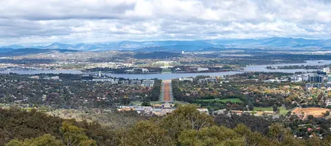
That line points the wrong way for sightseeing. The museums, galleries and Parliament House sit south of the city centre across Lake Burley Griffin, while the light rail heads north through Dickson into the newer suburbs. No light rail stop is anywhere near the Parliamentary Triangle, and an extension will not change that on this trip: the ACT Government's Stage 2A project page describes a 1.7km run from Alinga Street to Commonwealth Park opening to passengers in 2028, and Commonwealth Park is still on the northern shore.
Frequency is the line's strength. The operator's frequency guide shows trams every 5 minutes in the weekday morning peak, every 10 minutes through the middle of the day, and every 15 minutes on Saturdays and Sundays.
Buses that reach the institutions
Buses, not trams, are how you see Canberra's national collections. Transport Canberra runs a spine of rapid routes numbered R2 to R10, which the operator says run at least every 15 minutes between 7am and 7pm on weekdays; the central Canberra guide describes 15 to 30 minutes at other times, and local numbered routes every 30 minutes or less on weekdays.
This table matches each major institution to the route its own site or the Transport Canberra visitor page names.
| Institution | Route | Where it starts |
|---|---|---|
| National Gallery, Questacon, National Library | R2 or R6 | City Interchange |
| Parliament House | 57 | City Interchange |
| National Museum of Australia | 53 | City Interchange |
| Australian War Memorial | 54 | East Row, City Interchange |
| National Arboretum | None | No public transport |
Two of those deserve a note. The National Gallery of Australia says routes 2 and 6 travel via Barton and the nearest stop is about a six-minute walk from the entrance; the National Museum of Australia says route 53 runs seven days a week and stops on Lennox Crossing roughly 200 metres from its door. The War Memorial is the easiest of all — its visit page describes a 10 to 15 minute ride on the 54 from East Row at City Interchange, about 2km from the city centre.
Paying with MyWay+
MyWay+ is the ACT's ticketing system, and you do not need to buy anything before you travel. Transport Canberra's ways to pay page says a contactless bank card or a phone or smartwatch works directly at the validators, which are on every bus and at every light rail stop. The important limit: MyWay+ accepts Mastercard or Visa only, and does not accept American Express.
Cash is not on the list. Neither the ways to pay page nor the fare conditions page names cash as an accepted payment method, so plan to travel with a card or a phone and confirm on the operator's page if that is your only option.
Tap off as well as on. The fare conditions page states that you must tap on and tap off with the same card or device, and that failing to tap off applies an additional default fare. The 90-minute transfer and the daily cap together mean a day of hopping between clusters costs no more than the cap.
How far apart things really are
Canberra's institutions are not evenly scattered — they fall into a handful of clusters, and only movement between clusters needs a bus.
- The lakeside Triangle cluster. The National Gallery, National Portrait Gallery, Questacon, the National Library and the High Court all sit around Parkes Place and King Edward Terrace, close enough to move between on foot. Questacon's own site suggests allowing at least four hours for the venue and its surroundings.
- Parliament House, uphill. Parliament House sits at the top of the Triangle above the lakeside group, on route 57 rather than R2 or R6. Treat it as a separate stop rather than assuming you will stroll there between galleries.
- Acton Peninsula. The National Museum stands alone on its peninsula beside the lake's west basin, with route 53 as its link and lakeside shared paths as the alternative.
- Campbell. The Australian War Memorial is its own cluster, about 2km from the city centre at the head of Anzac Parade, with route 54 the named connection.
- Everything else. The Arboretum, Namadgi and Tidbinbilla are not in any walkable group and are covered separately below.
Opening hours nudge the sequence. The National Museum opens at 9am daily and closes at 5pm; the National Gallery runs 10am to 5pm daily; Questacon is open 9am to 5pm daily; the War Memorial's galleries open at 10am, begin closing progressively from 4pm, and its Last Post Ceremony is at 4:30pm.
A two-day shape
Two days works if you give each day one cluster in the morning and one in the afternoon, and accept that you will cross the lake exactly twice. The shape below is a sequence, not a timetable — check every departure in the journey planner on the day.
Weekends thin this out rather than break it. Rapid routes drop to the 15 to 30 minute band outside weekday business hours, and route 53 is confirmed as a seven-day service, so a Saturday–Sunday version works with longer waits between clusters. Evenings are the tighter constraint: once the institutions close at 5pm, bus frequency falls away well before the light rail does, so plan after-dark movement around the tram corridor or a rideshare.
Bikes, e-scooters and walking
Cycling suits Canberra's geography better than its bus timetable does. Transport Canberra's cycling page says more than 90% of buses carry bike racks holding two bikes each, and that light rail vehicles have four bike racks apiece, so a bike and a bus can be combined on the same fare. The central Canberra guide names the Lake Burley Griffin Circuit among its signposted routes, and that circuit passes the Triangle and Acton Peninsula.
Shared e-scooters and e-bikes are the flexible option for cluster-to-cluster hops. Transport Canberra's shared devices page names Lime as the operator, with an app map of approved riding areas that includes central Canberra.
Walking covers more than first-time visitors expect within a cluster, and almost none of the distance between them.
Where a car still wins
A car earns its cost for exactly the places the network does not reach, and the National Arboretum is the clearest case. Its own getting here page states plainly that there is no public transport to the National Arboretum Canberra, and puts it 6km from the city centre off the Tuggeranong Parkway, with bike racks on site for those who ride.
Namadgi National Park, Tidbinbilla Nature Reserve and the district's wineries sit further out again, beyond the Transport Canberra timetable entirely. If any of those is the reason for your trip, hire a car for one day rather than the whole stay and keep the two institution days on buses.
Arriving is not a reason to hire. Canberra Airport's public transport page describes the Rapid 3 bus reaching the city in under 20 minutes, every 15 minutes on weekdays and every 30 minutes on weekends, seven days a week including public holidays, with a ticket vending machine on the ground level next to baggage claim.
Check before you travel
Confirm three things on the Transport Canberra site the day before you set out: the current timetable for routes 53 and 54, the fares page for any change to the January 2026 prices quoted here, and the service alerts page. Stage 2A construction is affecting Commonwealth Avenue and Northbourne Avenue with closures and lane changes, and those alerts are where any bus diversion will appear.
This guide covers the national institutions in central Canberra by scheduled public transport. It does not cover accessible-travel details for individual buildings, tour operators, or services outside the Transport Canberra network — check each institution's own accessibility page for the first, and confirm regional transport separately.