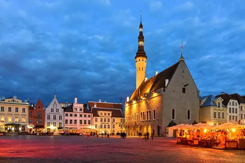
Tallinn's Old Town is not a rebuilt stage set. When you walk its streets, you are largely walking a street plan and a set of buildings that trace back to the 13th and 14th centuries, not a postwar recreation of one.
Why "genuinely intact" is not just marketing language
Many European old towns you can visit today are careful postwar reconstructions of cities badly damaged in 1939–1945, then rebuilt to resemble their prewar appearance. Tallinn's case is different. According to UNESCO's listing for the Historic Centre (Old Town) of Tallinn, the city is recognised as "an exceptionally complete and well-preserved medieval northern European trading city" whose street network — plots, streets and squares laid out in the 13th century — survives largely intact, along with buildings from the 14th to 16th centuries standing on their original footprints.
That does not mean nothing was ever damaged or altered. Tallinn went through the Soviet occupation, wartime bombing that hit some areas, and centuries of ordinary renovation like any living city. What UNESCO's assessment emphasises is continuity: protection rules dating to 1966 kept later development from erasing the medieval fabric, and the town kept functioning as an actual town — with homes, shops, offices and churches — rather than being frozen as a museum piece or rebuilt from scratch as a replica.
Two cities, one hill
The clearest way to read Tallinn's layout is to notice that it is really two adjoining towns that grew up under different rulers with different interests, and that difference is still visible in the stone.
Toompea, the upper town on the limestone hill, was the seat of secular and religious power — first the Danish and German nobility, later a succession of ruling powers, with the castle (now incorporated into Estonia's Parliament building), Alexander Nevsky Cathedral and Toomkirik (Dome Church) marking that role. It was walled separately from the town below it, and for long stretches of history the two areas were governed by different legal codes, with limited rights of movement between them.
The lower town belonged to the merchants and craft guilds — the commercial engine of the city, and the reason Tallinn mattered at all as a member of the Hanseatic League, the medieval trading network that linked Baltic and North Sea ports. Its narrow streets converge on the Town Hall Square, where merchants conducted business and the city's own government — independent in practice of Toompea's nobility — met in the Town Hall.
What the walls are actually telling you
Tallinn's fortifications were not built once and left alone; they were extended over centuries as siege technology changed, from simple stone curtain walls to the thicker, lower artillery-era bastions added when cannon fire made tall thin walls a liability. UNESCO's description notes that surviving sections still reach over 15 metres in places — tall enough that you are looking at genuine defensive engineering, not a decorative reconstruction sized for photographs.
The best way to register this is to look at where towers are close together versus spaced far apart. Dense clusters of towers usually mark a stretch that was considered vulnerable — often near a gate, where attackers would concentrate — while longer gaps between towers mark sections where the terrain itself (a steep drop, marshy ground) did most of the defensive work. Viru Gate, one of the surviving entrances, shows this logic clearly: it is flanked by round towers built to give defenders overlapping fields of fire onto anyone approaching the gate itself.
Reading a guild house or merchant house
A Hanseatic merchant house was a business, a warehouse and a home in one building, and its exterior tells you as much. Look for:
- A tall, narrow street frontage with a steep gabled roofline — narrow because city plots were taxed or valued by street frontage, so buildings grew upward and backward rather than wide.
- A hoisting beam projecting from the gable peak, sometimes still visible as a small wooden or metal arm — this was used to winch goods up into storage lofts under the roof, since the upper floors of a merchant's house were often warehouse space rather than living space.
- A stepped or scrolled gable rather than a plain triangular one, a common feature that marked wealthier or more prominent merchant families and guild buildings rather than ordinary houses.
- Carved or painted guild symbols near the entrance of former guild halls — the Brotherhood of Blackheads and the Great Guild both had dedicated buildings in the lower town, and their facades were built to advertise membership and status to the rest of the merchant community, not just to look attractive.
None of these features are unique to Tallinn — they appear across former Hanseatic ports from Lübeck to Riga — but Tallinn's density of surviving examples in one compact area is what UNESCO's listing singles out as unusual.
A route that follows the city's own logic
Rather than treating the Old Town as a list of separate sights, a walk that follows the historical division between the two towns reads the city the way it actually developed: start in the lower town at Town Hall Square, move outward through the merchant streets toward one of the surviving gates, then climb to Toompea by one of the two connecting streets to see the seat of power looking back down over the commercial town it never fully controlled. That contrast — trade below, authority above, each walled against the other for much of their shared history — is the single fact that makes the rest of the Old Town's architecture make sense.
What this guide does not cover
This guide focuses on why Tallinn's Old Town reads as authentic and how its layout and buildings communicate that history. It does not cover opening hours or ticket prices for specific museums and churches inside the Old Town, which change independently of the historical facts above and are worth checking directly with each site before you go.