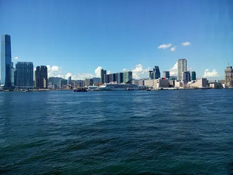
Hong Kong's skyline reads as a product of money. Walk it with the right two facts in mind and it reads as a product of land shortage instead — of a government that made new ground where there was none and housed half the population on it.
The evidence has not been curated into a single museum. It is scattered across two sides of the harbour in buildings that were never designed to be looked at. What follows is an order to see them in, with what each one actually proves.
Start where the public housing programme started
On Christmas night 1953, a fire tore through the squatter settlement at Shek Kip Mei. The Housing Authority's own accounts put the number made homeless at some 58,000 on one page and at more than 50,000 on another — a discrepancy in its own records that is itself worth noting.
The response was immediate and permanent. Temporary two-storey bungalows went up, a resettlement fund was created along with the post of Commissioner for Resettlement, and by the end of 1954 eight six-storey Mark I resettlement blocks stood in Shek Kip Mei. The Housing Authority describes that as the commencement of Hong Kong's public housing programme.
Mei Ho House is the last of them. Built in 1954 as Block H, later Block 15, now Block 41 of Shek Kip Mei Estate, it is the only surviving H-shaped public housing block in Hong Kong and the sole surviving Mark I resettlement block. It is a Grade 2 historic building, revitalised under the Development Bureau's Revitalising Historic Buildings Through Partnership Scheme.
| Visiting Mei Ho House | Detail |
|---|---|
| Museum hours | Tue–Sun and public holidays, 10:00–18:00 |
| Closed | Mondays except public holidays, and the first three days of Lunar New Year |
| Admission | Free for individuals and groups of 15 or fewer |
| Guided tours | Free public tours in Cantonese, English and Mandarin, no booking needed |
The museum's current public name is Heritage of Mei Ho House, and the building also houses a youth hostel. Seeing the original flat dimensions in person does more work than any statistic: the resettlement flat was small enough that the scale of what 58,000 people were being moved into becomes physical rather than abstract.
Then the settlement that housing law never reached
Kowloon Walled City Park occupies the site of the enclave that grew where neither administration exercised full control. The walled city itself was constructed between 25 November 1846 and 31 May 1847, covering around 6.5 acres behind stone walls with six watchtowers and four gates, garrisoned by 250 troops and more than 500 by 1898.
The walls came down during the Japanese occupation, quarried for construction materials. What grew afterwards the Leisure and Cultural Services Department describes in its own words as a semi-lawless enclave and festering squatter slum. Clearance was decided in 1987, demolition completed in April 1994, and the park opened on 22 December 1995 — 31,000 square metres in Jiangnan garden style, built at a cost of HK$76 million across eight scenic zones.
| Visiting the park | Detail |
|---|---|
| Opening hours | Daily 06:30–23:00 |
| Admission | Free |
| Movie set exhibition | Daily 09:00–19:00, free |
Read the two sites together and the argument completes itself. One is what the state built when it decided to house people; the other is what filled the gap where it did not.
Cross the harbour to where the sea used to be
The Central waterfront is the clearest place to see reclamation, because the Antiquities and Monuments Office has marked the successive shorelines with plaques on the Central and Western Heritage Trail.
Three markers do the work. Plaque C37, on the exterior wall of The Landmark on Pedder Street, marks the location of the original waterfront in 1841, before any land was reclaimed. Plaque C38 marks the reclamation carried out between 1843 and 1865. Plaque C39, on the footbridge linking Connaught Road Central near Chater House, marks the point to which the waterfront was extended northwards during the praya reclamation of 1890 to 1904.
A foundation stone in Chater Garden commemorates the commencement of those praya reclamation works in 1890.
Walk from Pedder Street to Connaught Road with those three in sequence and you cross about sixty years of made ground in ten minutes. The distance is the fact.
Western Market, at 323 Des Voeux Road Central, is the nearby survivor. The north block dates from 1906, the south block of 1858 having been demolished in 1980, and the building was made a declared monument in 1990 before conversion in 1991 into a centre for traditional trades, arts and crafts. Its four corner towers with decorative brickwork are the reason to look up.
Opening hours are not published on the monument listing and tenant shops set their own, so treat this as a stop on the way rather than a destination with a schedule.
Add one more if the day allows
Tai Kwun, the former Central Police Station compound, became a declared monument in 1995 and comprises three groups of buildings — the former Central Police Station, the Central Magistracy and Victoria Prison — erected between the mid-19th and early 20th centuries. The Barrack Block of 1864 housed 200 single constables and sergeants; the Police Headquarters Block of 1919 fronts Hollywood Road with Doric columns and royal insignia.
Operations ceased in December 2004 and the site reopened in 2018 as a centre for heritage and arts, receiving a 2019 UNESCO Asia-Pacific Award for Cultural Heritage Conservation.
The site opens 08:00 to 23:00 and is free to enter, with the visitor centre open 10:00 to 20:00 and heritage exhibitions from 11:00 to 19:00, the Main Heritage Gallery and Operation Central opening at 10:00. Individual exhibitions and programmes may charge.
What the numbers behind the walk actually say
Reclamation is not a historical episode that ended. About 6,954 hectares had been reclaimed as at 2016 — roughly 7% of Hong Kong's land area, about half the size of Lantau Island. New towns built on reclaimed land, including Tsuen Wan, Sha Tin, Tuen Mun, Tai Po, Tseung Kwan O and Tung Chung, housed 3.47 million of Hong Kong's 7.35 million residents that year, about 47%.
The pace, though, changed sharply. Between 1985 and 2004 reclamation ran at 500 to 700 hectares every five years. After the Protection of the Harbour Ordinance of 1997, only 84 hectares were reclaimed between 2005 and 2009 and 124 hectares between 2010 and 2014.
Public housing follows the same pattern of scale. As at 2024, 44.7% of the population lived in public housing — 29.4% in public rental housing and 15.3% in subsidised sale flats — across roughly 871,000 public rental flats and about 1,328,000 public housing flats in total.
Doing the walk in one day
Take Sham Shui Po and Kowloon Walled City Park in the morning while the museum and exhibition are open, then cross to Central in the afternoon for the shoreline plaques, Western Market and Tai Kwun, which stays open late.
The order matters because of the timed-entry cap at the Walled City exhibition. Everything on the Hong Kong Island half of the walk is either outdoors or open until the evening, so a delay there costs nothing.
Check the Mei Ho House museum day before setting out, since Monday closes it and a Monday plan collapses around that one fact. Figures and hours here were confirmed against government and operator pages on 17 September 2026; the reclamation total is a 2016 figure, the most recent published, and the public housing shares are for 2024.