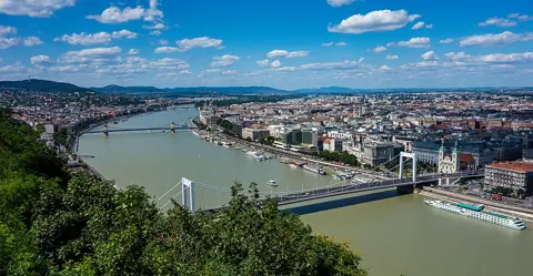
Why the river matters more here than in most cities
Plenty of European cities have a river running through them without splitting into two distinct identities on either bank. Budapest is different because, for most of its history, there was no way to cross the Danube without a boat or a seasonal pontoon bridge, so Buda and Pest genuinely developed as separate places with separate economies, separate governments and separate town councils — not as two halves of one city that happened to be divided by water.
According to the Budapest City Archives' own history of the city, the 1873 unification of Buda, Pest and Óbuda into a single municipality is described as the logical conclusion of building the Chain Bridge, the first permanent crossing of the river, which made governing the two sides as one entity practical in a way it hadn't been before.
What each side actually was
The names themselves are worth pausing on, too. "Budapest" is a nineteenth-century compound built from "Buda" and "Pest" specifically to reflect the merger — it did not exist as a place name before 1873, which is a useful reminder that the unified city is younger than either of its component halves, both of which had been established towns for centuries by the time the new combined name was adopted.
Before 1873, the three settlements had genuinely different jobs.
Buda was the royal seat, going back roughly to the fifteenth century, built up around the Royal Palace on Castle Hill. Its geography — hills, a defensible high point, winding older streets — reflects that role: a place built for a court and a fortress, not for trade.
Pest, on the flat eastern bank, developed as the commercial and cultural centre, and the City Archives note it eventually achieved equal civic rank with Buda under King Matthias in the medieval period, even while Buda held the crown and the palace. Its flatness made it the natural place for markets, warehouses, and later the wide boulevards and ring roads that define its layout today.
Óbuda, the oldest of the three, sits on the site of Aquincum, the Roman settlement that predates the medieval towns of Buda and Pest entirely. It's a much smaller part of the story today — folded into the modern district of Óbuda-Békásmegyer — but it's the reason Budapest's continuous urban history stretches back to Roman times rather than starting in the Middle Ages.
What unification actually changed
The City Archives describe a Council of Public Works established after 1873 specifically to plan the newly unified city's future, and the results are still what you walk through in central Budapest: broad boulevards like Andrássy út, now home to the House of Terror museum, and the ring roads (körutak) that structure how Pest is organised today. This was a deliberate, planned modernisation push meant to turn three separate towns into what the Archives describe as a modern, world-class city — not organic growth, but a specific post-unification building programme.
How to read the two sides today
The practical result of this history is that Buda and Pest still don't feel like arbitrary halves of the same city. Buda is hillier, quieter, more residential and more built around historic set-piece sights — the Castle District, Gellért Hill, the Buda hills further out — while central Pest is flatter, denser, and organised around commerce, dining, nightlife and the grand nineteenth-century boulevards built in the unification era. Crossing the river changes the pace of a walk more noticeably here than in most river-divided European cities, precisely because the two sides spent centuries developing on genuinely separate tracks rather than as neighbourhoods of one city from the start.
Before you plan your route## Margaret Island: ground that belongs to neither side
Margaret Island, the long park island sitting in the Danube between the two banks, is worth knowing about specifically because it sat outside the rivalry between Buda and Pest for most of their separate history — a green, sparsely built space rather than an extension of either town's street grid. Today it functions as shared civic ground for the unified city: a car-free park used by both sides equally, connected by bridges to both Buda and Pest rather than belonging to either. If Buda and Pest read as two different characters, Margaret Island is closer to neutral territory between them, and a useful place to physically feel that the city really was stitched together from separate pieces rather than growing outward from one centre.
Decide roughly how much time you want on each side rather than trying to zigzag across the river repeatedly in one day — Buda rewards a slower, hillier half-day built around the Castle District and its views, while Pest suits a walking route strung between the boulevards, the river embankment and the inner-city squares. This guide does not cover a turn-by-turn walking itinerary for either side; it's meant to explain why the two halves feel different before you plan one.