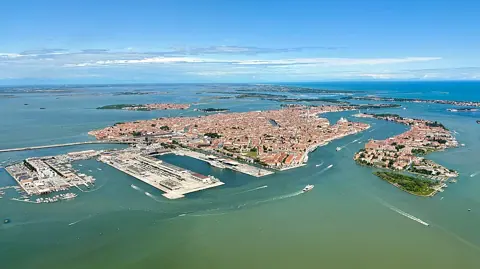
A Venice tide reading of "+110 cm" is not 110 cm of water in the street. It is 110 cm above a fixed historical reference, and the ground you walk on sits well above that reference in most of the city. This is the single most useful thing to understand before you read a Venice tide forecast, because it explains why a number that sounds alarming often means a puddle at one end of Piazza San Marco and nothing at all at the station.
What the tide numbers mean
Every Venice tide figure is expressed in centimetres above the Zero Mareografico di Punta della Salute (ZMPS), the conventional level the city adopted in 1897 (Comune di Venezia, Venezia e l'acqua alta, checked 15 September 2026). The city altimetry compiled by Insula spa for the Centro Previsioni e Segnalazioni Maree defines ZMPS as the mean sea level recorded by the first fundamental altimetric network of 1897 (Venezia altimetria, 2009 update, checked 15 September 2026). It is a nineteenth-century sea, not today's one, and it is the scale used in the MOSE closure records as well as in the public bulletin.
The table below matches tide levels on that scale to what is actually under water, using the Comune's own figures.
| Tide level (ZMPS) | What it reaches | Public ground flooded |
|---|---|---|
| +80 cm | Attention threshold; commonly called acqua alta | Not stated |
| +82 cm | Piazza San Marco paving starts to wet | Not stated |
| +100 cm | Low quaysides and the lowest campi | 5 percent |
| +105 cm | Rialto, including waterbus landing stages | Not stated |
| +110 cm | MOSE closure threshold | About 12 percent |
| +140 cm | Classed as an exceptional high water | 59 percent |
Sources for the table: the Centro Maree states that a tide above the +80 cm attention threshold is commonly called acqua alta, that +100 cm floods 5 percent of public ground, that around +110 cm roughly 12 percent of the city is affected and that +140 cm reaches 59 percent (Comune di Venezia, La marea, checked 15 September 2026); the Piazza San Marco, Rialto and station reference points come from the Centro Maree's forecast-reading guide (Interpretare la previsione di marea, checked 15 September 2026).
When acqua alta actually happens
Venice's flood season is defined administratively, not just meteorologically: the Comune activates its pedestrian walkway plan from 15 September to 30 April each year (Comune di Venezia, Percorsi su passerelle, checked 15 September 2026). If you are travelling between May and early September, the city itself does not expect to need raised walkways, though the tide is never formally switched off.
The record of exceptional events points the same way, only harder. Of the highest levels the Comune lists, the top six fall on 4 November 1966 (+194 cm), 12 November 2019 (+187 cm), 22 December 1979 (+166 cm), 1 February 1986 (+158 cm), 1 December 2008 (+156 cm) and 29 October 2018 (+156 cm) (Le acque alte eccezionali, checked 15 September 2026). Late autumn dominates; nothing in the list falls in high summer.
How often the barriers are needed varies enormously from one year to the next, which is why "it floods in November" is a weak basis for planning. The Autorità per la Laguna di Venezia publishes the season-by-season count.
| MOSE season | Closures |
|---|---|
| 2020/2021 | 20 |
| 2021/2022 | 13 |
| 2022/2023 | 19 |
| 2023/2024 | 32 |
| 2024/2025 | 23 |
| 2025/2026 | 49 |
Figures from the Autorità per la Laguna's operations log (Operatività M.O.S.E., checked 15 September 2026); the same page counts 32 closures in calendar 2026 with the year still running, against 27 in 2025 and 11 in 2022. The 2025/2026 season's logged operations begin on 10 September 2025 and end on 15 May 2026, which is a wider window than the walkway season.
How MOSE is raised
MOSE is a set of hinged gates lying flat on the seabed, not a wall. There are 78 mobile gates plus spares, split across four barriers: 21 at Lido North (Treporti), 20 at Lido South (San Nicolò), 19 at Malamocco and 18 at Chioggia (MOSE Venezia, Paratoie, checked 15 September 2026). Each gate normally sits inside a caisson filled with water; compressed air is injected to empty it, and the gate rotates up around two hinges until it stands against the sea. Once up, the gates oscillate freely with the waves rather than resisting them rigidly.
The rule for raising them is a forecast rule with a single published number. The Autorità per la Laguna states that raising the MOSE barriers is triggered by a forecast probability of high tide above 110 centimetres (Operatività M.O.S.E., checked 15 September 2026). The operator's own description adds that the final closure decision rests on direct measurement of water levels rather than the forecast alone, so the system can respond to a sudden change shortly before the event (MOSE Venezia, Il MOSE, checked 15 September 2026).
Two details in the log matter to anyone reading a closure announcement. Closures are frequently partial, recorded as "Solo Lido" or "Solo Lido e Chioggia", so a raised MOSE does not always mean a sealed lagoon. And the published durations overstate the protection: the Authority notes the manoeuvre becomes hydraulically effective about 10 minutes after the start and stops about 15 minutes before ballasting is reported complete, making the effective duration roughly 25 minutes shorter than the figure in the table.
What MOSE does not stop
MOSE does nothing about the floods most visitors will actually meet. The trigger sits at a forecast above +110 cm, and Piazza San Marco is already wet from about +82 cm, so the entire 80-to-110 cm band — the ordinary, frequent acqua alta — passes into the lagoon with the gates flat on the seabed. A closed MOSE season is not a dry San Marco.
The system's own material is direct about this. The operator states that the barriers do not address the frequent, low-level flooding of the lowest local areas, which is why separate local defence works exist alongside them (MOSE Venezia, Il MOSE, checked 15 September 2026). The same page gives the design envelope at the other end: protection against tides up to 3 metres and against sea level rise of up to 60 cm over the next hundred years.
Walking on the passerelle
The passerelle are the city's answer to the tides MOSE ignores, and they are a seasonal installation rather than permanent street furniture. From 15 September to 30 April the Comune activates the Piano di Viabilità Pedonale, a plan of raised walkway routes whose management and placement is contracted to VERITAS SpA, based on Centro Maree forecasts (Comune di Venezia, Percorsi su passerelle, checked 15 September 2026).
Their stated limit is precise. The published maps guarantee a dry-foot route up to a tide of +120 cm; above that, the Comune says some routes may become unusable. That is the number to hold in your head when a forecast crosses 120: not that the city is impassable, but that the walkway network stops being a guarantee.
Sirens, boats and forecasts
The warning sirens tell you the predicted level, and you read them by counting. After an attention-getting siren tone, the system plays one sustained note for +110 cm, two rising notes for +120 cm, three for +130 cm and four for +140 cm and above, through loudspeakers installed in the city, on the Venetian shoreline and on the islands (Comune di Venezia, Sirene allertamento acqua alta, checked 15 September 2026). Note what the scale omits: the published tone table starts at +110 cm, so the ordinary tides that wet St Mark's get no siren at all, and the page does not state how far ahead of the peak the signal sounds.
Waterbus service degrades in steps rather than all at once, and the steps start low. ACTV suspends the S. Marcuola stop towards Rialto and San Marco above 85 cm; above 95 cm it reroutes lines 2, 4.2, 5.2 and 6, shortens 4.1 and 5.1, and suspends line 3 entirely; above 120 cm Zattere towards San Marco and Lido closes; above 125 cm the line 2 access ramps at Rialto become unusable; above 135 cm the Vivarini bridge at Murano closes (ACTV, Acqua alta servizi di navigazione previsti, checked 15 September 2026).
The forecast itself comes from one body. The Centro Maree was formally established in 1980 after the 1979 flood, following a first tide observation service the Comune set up in the early 1970s, and it publishes a bulletin online, runs an automated telephone service on 041 2411996 with 120 auto-search lines, and operates a Telegram bot at t.me/Centromareevenezia_bot (Comune di Venezia, Il Centro Maree, checked 15 September 2026).
Before you fix your travel dates
Check the Centro Maree bulletin the evening before each day in Venice, not the week before, because the meteorological component of the tide is a short-range forecast and the astronomical part alone tells you little. If the number for your day is under 105, expect nothing beyond damp corners of Piazza San Marco. Between 105 and 120, expect the passerelle to be out and some waterbus stops to be skipped. Above 140, expect to walk.
Two things this guide does not settle. It does not tell you whether your specific hotel, restaurant or ground-floor apartment floods, because the Comune's altimetry is published for public pedestrian surfaces rather than private thresholds, and only the property can answer that. And it does not cover Chioggia, the Lido or the mainland, whose exposure and defences are described in their own terms in the sources above rather than in the figures used here.