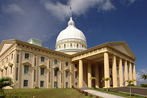
The common mistake is to think of Ngerulmud as a city. It is not. The Palau Visitors Authority describes Ngerulmud as the area within Melekeok State where the capitol buildings opened in 2006, on a hilltop with views of the eastern coastline. There is no downtown around it. Hotels, dive shops and most of the population are in Koror, an island state joined to Babeldaob by a bridge.
Babeldaob itself is not an outlying island either. According to the Visitors Authority it is 27 miles long and up to 15 miles wide, the second-largest landmass in Micronesia. Every visitor who flies in lands there first.
Why isn't Koror the capital of Palau?
Because the Constitution never meant it to be permanent. Article XIII, Section 11 of the Constitution of the Republic of Palau reads: "The provisional capital shall be located in Koror; provided, that not later than ten (10) years after the effective date of this Constitution, the Olbiil Era Kelulau shall designate a place in Babeldaob to be the permanent capital."
The Olbiil Era Kelulau is the national congress. Its House of Delegates has one member for each of Palau's 16 states, and each state also elects its own governor and legislature. Several of them, including Airai, Melekeok, Ngardmau and Ngarchelong, are on Babeldaob rather than in Koror.
The U.S. Government Accountability Office noted in 2008 that "the majority of the population lives in the single urban center, Koror, although the capital was officially moved in 2006 to Melekeok, on Babeldaob, Palau's largest island." Moving the ministries did not move the population. A 2007 business report prepared for the U.S. Interior Department put Koror's share at 70%, with about a quarter of residents on Babeldaob.
Why the move took until 2006
A capital on Babeldaob made little sense without a way to reach it. Two pieces of infrastructure had to come first.
The bridge
The original bridge between Koror and Babeldaob collapsed in September 1996. According to the Government of Japan, a replacement built with Japanese grant aid started in November 1999 and opened in 2002 as the Japan-Palau Friendship Bridge. The same page explains why the loss hurt so much: the bridge carries power and water lines from Babeldaob, which hosts the airfield and power station, to Koror, where most people live.
The Compact Road
The second piece was a road around Babeldaob paid for by the United States under the Compact of Free Association, the agreement that took effect on 1 October 1994 and marked Palau's independence. GAO records that Compact section 212(b) set aside USD 149 million for it and required completion by 1 October 2000. It was not finished until 1 October 2007.
The U.S. Army Corps of Engineers, which managed the project, describes a two-lane road 53 miles long with seven major bridges, built by Daewoo Engineering and Construction of Seoul under a contract awarded in March 1999. It gave access to the new capital site at Melekeok. The Corps' resident engineer was quoted at the opening: "The journey that used to take an entire day now takes two hours."
The road is now Palau's responsibility. GAO recorded U.S. and Palauan concerns about keeping it in good condition, and the Interior Department announced USD 2 million a year for its maintenance through fiscal 2024.
Where things actually are for a visitor
This guide is filed under Ngerulmud, but most of what a visitor does in Palau happens elsewhere.
| Place | Island and state | Why a visitor goes |
|---|---|---|
| Roman Tmetuchl International Airport | Babeldaob, Airai (Ngerusar) | Arrival, immigration, Palau Pledge stamp |
| Koror | Koror State | Hotels, dive and Rock Islands boats, visa extensions |
| National Capitol | Babeldaob, Melekeok (Ngerulmud) | The capitol buildings and east-coast view |
| Lake Ngardok | Babeldaob, Melekeok | Freshwater lake and bird habitat |
| Ngardmau Waterfall | Babeldaob, Ngardmau | 20 to 30 minute trail to the falls |
| Badrulchau stone monoliths | Babeldaob, Ngarchelong | Archaeological site at the northern tip |
The airport operator gives its address as Ngerusar, Airai, a 20 to 30 minute drive from Koror. The Visitors Authority describes Lake Ngardok as the largest natural lake in Micronesia and a nesting area for saltwater crocodiles. It dates the Badrulchau site as far back as AD 161 and says the pillars may be the remains of the largest meeting house ever built in Palau.
Ordinary visitor paperwork does not take you to the capital. The Immigration office that handles tourist visa extensions is in downtown Koror. Offices at the capitol, such as the Passport Office, mainly serve Palauans.
How do you get to Ngerulmud from Koror?
By car or on a tour. The airport warns that no cabs wait at the terminal, so arrange transport in advance. It lists several rental companies and a taxi number run through the Visitors Authority.
The Visitors Authority puts the drive from Koror to Ngarchelong, at the far north of Babeldaob, at about an hour on the Compact Road, and says the capitol sits a short distance off the main highway. The U.S. State Department notes that Palau has no traffic lights and a national speed limit of 25 mph, so do not plan tight connections.
The state and site fees for the waterfall, the monoliths and the lake were not listed on the official pages we read. Ask your rental company or guide what each stop charges before you set off.
If your trip is mainly Rock Islands diving, stay in Koror and treat Ngerulmud as optional. If you have a spare day and a driver's licence, the capital is the natural midpoint of a loop around Babeldaob. Before any lagoon trip, read our guide to the Palau Pledge and environmental fee and the Jellyfish Lake permit guide.