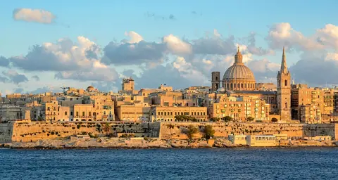
Most old European city centers grew in layers over centuries, streets bending around older buildings and older decisions. Valletta didn't grow that way — it was designed once, as a single fortified city, and the grid you walk today is close to the plan its builders drew up in the first place.
Built after a siege, not before one
Valletta exists because of the Great Siege of 1565, when the Knights of St John successfully defended Malta against a major Ottoman assault. According to UNESCO's own listing for the city, the Knights founded Valletta in 1566, immediately after that siege, on a strategic peninsula positioned between two natural harbors — a location chosen specifically for its defensive value, not for existing settlement or convenience.
This origin story matters for how you read the city: Valletta wasn't a town that later needed fortifying. It was conceived from the start as a fortress with a city built inside it, in that order.
A single Renaissance plan, not organic growth
UNESCO describes Valletta as "a uniform grid plan within fortified and bastioned city walls" — a genuinely planned Renaissance city reflecting the era's ideas about ideal urban design, built by the Knights working with some of the era's most respected European military engineers. That grid has been respected through the centuries since, which is why walking Valletta today still traces something close to its 16th-century layout rather than a later reconstruction laid over medieval streets.
Later additions came from 18th-century engineers and architects, adding structures like the Manoel Theatre and the Church of the Shipwreck of St Paul, but these were insertions into the existing plan rather than departures from it.
Why the fortifications look the way they do
Valletta's walls and bastions were built around the natural shape of the peninsula rather than a simple straight-line perimeter, using the site's dramatic topography — cliffs and harbor edges — as part of the defense itself. UNESCO's listing describes this combination of bastioned walls and natural terrain as central to what makes the site historically significant, alongside the density of what survives inside those walls: roughly 320 monuments packed into about 55 hectares, which UNESCO calls one of the most concentrated historic areas in the world.
That density is part of why Valletta rewards slow walking over a quick pass-through: almost every street holds something from the fortress-city period, rather than a handful of highlighted landmarks surrounded by later infill.
How to actually read the grid on foot
- Enter through City Gate and notice immediately that the main street running through the city (Republic Street) runs in a straight, uninterrupted line — this is the spine the whole grid was organized around.
- Walk a perpendicular side street toward the harbor edge and notice how it runs straight down to a bastion or a harbor view rather than curving or dead-ending — cross streets were planned to connect the spine to the fortifications, not to wander.
- Look at where streets meet the outer walls: bastions bulge outward at points chosen for sightlines along the walls, a detail that reads as decorative from inside the city but was originally functional.
- Compare the regularity of the grid to older Maltese towns like Mdina, which grew organically over a much longer period — the contrast makes Valletta's planned character obvious once you've seen both.
What this changes about how you plan a visit
Because Valletta is small, walkable and grid-based, it doesn't need the kind of multi-day, transit-heavy itinerary a larger capital would. A single focused day on foot covers the grid meaningfully; the value is in noticing the plan itself, not in covering distance. Save time to stand at a bastion looking out over the harbor rather than treating the walk as a checklist of named streets.
Comparing Valletta to Malta's older towns
Seeing Valletta alongside an older Maltese town like Mdina or Birgu sharpens the point about planning. Mdina grew over many centuries with streets that curve, narrow and dead-end according to accumulated decisions rather than a single design, and Birgu shows its own layered fortification history predating Valletta's founding. Valletta, by contrast, reads as a single decision executed at scale: one plan, one relatively short building period, and a grid that has held up structurally against the pressure of centuries of continued use. Visiting even one of these older towns on the same trip makes Valletta's planned character far easier to recognize than reading about it in isolation.
Give yourself more time than you expect for this walk. The grid looks simple on a map, but the density of monuments packed into such a small footprint means a genuinely thorough pass takes considerably longer on foot than the short physical distance between City Gate and the harbor bastions would suggest.
What this guide does not cover
This guide does not cover Valletta's individual museums and churches in detail, or the city's 20th-century history including wartime damage and reconstruction, both of which deserve separate, focused coverage rather than a mention here.