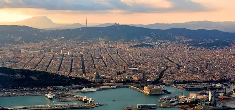
Every crossroads in Barcelona's Eixample is an octagon rather than a cross. The corner of each block is cut back at an angle, four cut corners meet at each junction, and the result is an open space of roughly 2,000 m2 that Barcelona City Council describes as at present used exclusively for traffic (Ajuntament de Barcelona, Eixample | Superilles, checked 15 September 2026).
The district's design put generous public space at every corner and then gave it to vehicles. The city is now converting a first set of those octagons into squares, which changes where it is pleasant to walk. One immediate condition: the traffic-calmed area of Sant Antoni is under construction until June 2027.
What the cut corners actually do
The cut corner is a piece of traffic engineering that has become a supply of public space. Barcelona City Council's own description of the district refers to "the city's characteristic street corners, or chamfers" and explains that new squares are appearing at the crossroads of green streets precisely because those chamfers already widen the junction; the roughly 2,000 m2 involved is currently given over to traffic and is being redesigned with vegetation, permeable paving and play areas (Ajuntament de Barcelona, Eixample | Superilles, checked 15 September 2026). In Catalan the cut corner is a xamfrà; you will see the word on estate-agent boards and menus long before anyone explains it.
The city's own visitor pages describe the Eixample as built in the latter part of the 19th century under the plan of the engineer Ildefons Cerdà, to expand Barcelona beyond its walls, and note its wide streets, all equal in size, with "particular octagonal-shaped city blocks" (Ajuntament de Barcelona, L'Eixample | Meet Barcelona, checked 15 September 2026). Barcelona City Council's history pages place the Cerdà plan immediately after the demolition of the medieval walls, in a city whose population was growing on the back of 19th-century industry (Ajuntament de Barcelona, Modern industrial city, checked 15 September 2026).
One thing this guide will not tell you is what Cerdà personally intended for the inside of each block. The claim that he meant every block to be built on only two sides, with an open garden between, is repeated constantly; we did not find it stated on any Barcelona City Council or MUHBA page we read, so we are not presenting it as fact here. What the museum does say is that the Eixample was one of the most ambitious and most debated planning processes in Barcelona's modern history, shaped by tension between technical reasoning, the architectural proposals of the period and property interests (MUHBA, Raó, passió i negoci en la construcció de l'Eixample, checked 15 September 2026).
Six neighbourhoods inside one grid
The Eixample is not one district in practice but six named neighbourhoods, and knowing which one you are in saves more time than any map. Barcelona City Council's visitor pages set them out with their landmarks; the table below matches each name to what anchors it.
| Neighbourhood | What anchors it |
|---|---|
| Dreta de l'Eixample | Starts at Plaça de Catalunya, organised around Passeig de Gràcia; Casa Batlló and Casa Milà (La Pedrera) |
| Antiga Esquerra de l'Eixample | Residential; the University of Barcelona building on Gran Via, Hospital Clínic and the Faculty of Medicine |
| Nova Esquerra de l'Eixample | Parc de Joan Miró, on the site of a former slaughterhouse |
| Sant Antoni | Between Paral·lel and Gran Via de les Corts Catalanes; Mercat de Sant Antoni |
| Sagrada Família | Arranged around Gaudí's church of the same name |
| Fort Pienc | Between Plaça de les Glòries and Passeig de Sant Joan; Teatre Nacional de Catalunya, L'Auditori, Mercat dels Encants |
Source: Ajuntament de Barcelona, L'Eixample | Meet Barcelona, checked 15 September 2026.
Two of those names do the heavy lifting for orientation. Dreta means right and Esquerra means left, and the Dreta is the half organised around Passeig de Gràcia, so an address described as being "a l'Esquerra" tells you which side of the district to head for before you have read the street name. Sant Antoni and Fort Pienc sit at opposite ends of the Eixample and feel different from the middle of the grid.
The green axes and the new squares
The green axes are the streets the city has chosen to make comfortable to walk along, and they are the lines to plan a day around. Barcelona City Council's English pages call them green hubs or green streets; in Catalan they are eixos verds, and a single one is an eix verd, which is what the signage and local press use. The stated aim for the district is that every Eixample resident should have a square or a green street within 200 metres of home, and the programme as a whole covers 21 green streets totalling 33 km, plus 21 new squares, adding 33.4 hectares of pedestrian space and 6.6 hectares of urban greenery (Ajuntament de Barcelona, Eixample | Superilles, checked 15 September 2026).
The first four axes were tendered together and are the ones you are most likely to meet. The table gives the length and surface area the City Council put out to competition for each.
| Green axis | Length | Surface area |
|---|---|---|
| Consell de Cent | 2.8 km | 64,540 m2 |
| Girona | 0.75 km | 16,244 m2 |
| Rocafort | 0.6 km | 12,797 m2 |
| Comte Borrell | 0.5 km | 10,010 m2 |
Source: Ajuntament de Barcelona, Barcelona Superblock Presentation (English), checked 15 September 2026.
The four squares in the same programme sit where two axes cross, and all four are on Consell de Cent: at Rocafort, at Comte Borrell, at Enric Granados and at Girona, each about 2,000 m2 (same presentation, checked 15 September 2026). This is the clearest expression of the whole idea. A chamfered junction that was a traffic space becomes a neighbourhood square, and the octagon that made room for turning cars is what makes the square possible.
What the district does not have
The Eixample is the district of Barcelona with the fewest green areas, and the City Council says so directly. Its own account of why the superblock model was applied here first names the pressure from motorised transport, the pollution and the noise, and states plainly that this is the district with the lowest number of green areas (Ajuntament de Barcelona, Eixample | Superilles, checked 15 September 2026). The city's remedy is to build small squares into the street network rather than to open up the interiors of the blocks.
It also does not have a finished network. The programme describes a target of at least 10% of street surface given over to greenery, up from the 1% that today's streets carry, and as many as 4,000 new trees across the 21 hubs (Ajuntament de Barcelona, This is what 21st-century streets will be like, checked 15 September 2026). Those are stated targets for a rolling programme, not a description of what is on the ground on the day you arrive.
Walking the grid without getting lost
Uniformity is the Eixample's navigational trap: because every junction is the same octagon and every street is the same width, one crossroads gives you almost no information. Steer by the cross street rather than by appearance, and use the few streets that break the pattern as fixed points: Gran Via de les Corts Catalanes, Passeig de Gràcia, Rambla de Catalunya, and Avinguda Diagonal, which crosses the grid at an angle.
Walking distances are longer than the map suggests, and the chamfer is part of the reason. At each junction the pavement follows the cut corner instead of turning a right angle, so a diagonal route across several blocks means a series of short detours around the octagons and more waiting at crossings than a straight line would imply. Where you can, pick a single street and stay on it.
The 21st-century street model tells you what a completed axis will feel like: a single level from façade to façade with no kerb between pavement and road, panot as the main paving with granite marking heritage buildings and unique sites, trees down the centre of the street rather than at the edges, lower street lamps placed centrally, and vehicles treated as guests that must turn at corners rather than run straight through (Ajuntament de Barcelona, This is what 21st-century streets will be like, checked 15 September 2026). Where you see that, you are on a completed section. Where the kerb reappears, you are not.
Where the plan is explained
MUHBA, the city's history museum, runs the one guided treatment of this subject that comes from the city itself. Its urban itinerary on the building of the Eixample starts at the Jardins de la Torre de les Aigües at Carrer de Roger de Llúria 52, runs 2 hours 30 minutes, and costs EUR 10, or EUR 7 for museum Friends; the museum notes that visits and itineraries are given in Catalan unless stated otherwise, with other languages available for groups (MUHBA, Raó, passió i negoci en la construcció de l'Eixample, checked 15 September 2026). Dates are scheduled individually, so check the museum's agenda rather than assuming a weekly slot.
If you would rather read the grid than walk it with a guide, MUHBA also publishes the Historical Charter of Barcelona, a web application showing the growth of the city's urban fabric between 150 BC and 2010 through 29 chronological maps with historical commentary and overlay layers (MUHBA, Historical Charter of Barcelona, checked 15 September 2026). Seeing the walled city and the grid on the same frame explains the shape of the district faster than any description.
Before your first walk across the grid
Pick one green axis and walk its length rather than zig-zagging across the district. Consell de Cent is the long one at 2.8 km and runs right across the middle of the district, passing the junctions with Rocafort, Comte Borrell, Enric Granados and Girona where the four new squares sit. That single line gives you the chamfers, the squares and the completed street model in one walk, and it keeps you off the traffic corridors.
Then check two things before you set out. Confirm on Barcelona City Council's Superilles pages which sections are finished, because the programme is being delivered street by street and the maps published with it are proposals as well as records. And if your accommodation is in Sant Antoni, expect construction hoardings and diverted pavements until June 2027, and allow extra time for the walk to Paral·lel or the market.